Did you know the Great Lakes have three different Ordinary High Water Marks?
 Print
Print Email
EmailDetermining where the Great Lakes water's edge is can be a challenge. An Ordinary High Water Mark (OHWM) helps distinguish and categorize different areas near the Great Lakes.

Michigan is a state defined and shaped by the Great Lakes with its 3,288 miles of shoreline. That shoreline is a part of a very dynamic Great Lakes system. In this system, the water levels can vary greatly over multi-decadal time periods of both high and low water. That variation helps to give Michigan its famous Great Lakes shoreline but also poses challenges for land use decision makers. One of those challenges is determining where exactly the Great Lakes water’s edge is.
With average seasonal water level changes of 12 inches on Lake Michigan-Huron, and even greater long-term fluctuations, having an established boundary to measure from is crucial to measuring things like setbacks and to determine where regulations from federal, state and local jurisdictions apply. (Learn more about lake levels at Michigan Sea Grant's website.)
One such established line that federal, state, and local governments use is called the Ordinary High Water Mark (OHWM).
State, local, and natural OHWM
In Michigan, the OHWM often refers to the line set by state in the Natural Resources and Environmental Protections Act (NREPA), Part 325 Great Lakes Submerged Lands (MCL 324.32501 et seq). Additionally, OHWM can refer to a local OHWM or the natural OHWM, both of which may be different than the line established by the state. Each of these three markers helps distinguish and categorize different areas near the Great Lakes.
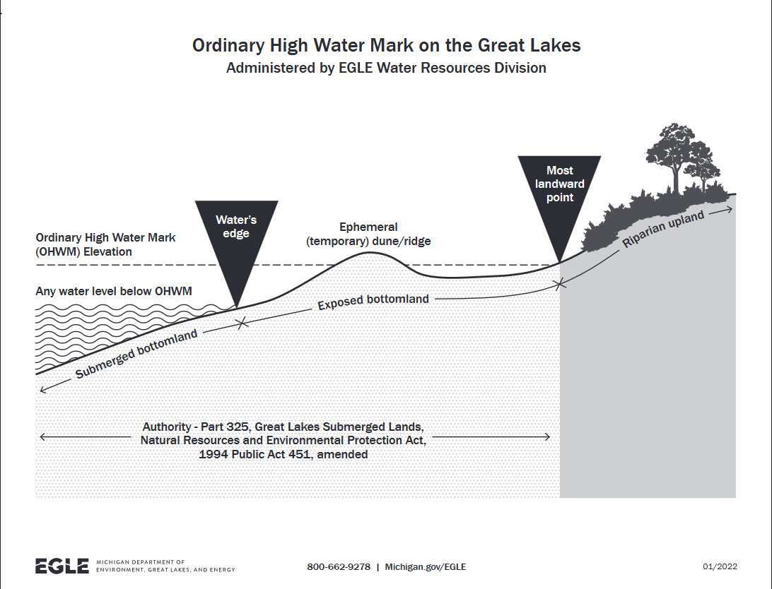
The state Ordinary High Water Mark is an elevation set through Part 325 of NREPA, tied to the International Great Lakes Datum (IGLD). The IGLD is the vertical reference system used to base measurements of water levels; it is managed bi-nationally by the Coordinating Committee on Great Lakes Basic Hydraulic and Hydrologic Data. The state line is drawn by extending the IGLD for a particular lake toward the shore and drawing a line where it intersects with the most landward point.
Michigan's Department of Environment, Great Lakes and Energy’s (EGLE) website on the OHWM includes a chart of the IGLD (1955 & 1985) for all the Great Lakes. The federal government, through the US Army Corps of Engineers, also regulates activities waterward of the OHWM. In addition, the IGLD is expected to be updated in 2027, changing the elevation. For more information on the IGLD update process visit the IGLD update page on the Great Lakes Coordinating Committee’s website.
Coastal communities may also have a local OHWM defined by local ordinance, such as a zoning ordinance. These local ordinances may use the same OHWM as set by state law, or with some minor modifications like Chikaming Township in Berrien County does. The Chikaming Township zoning ordinance defines a “Regulatory Ordinary High Water Mark (ROHWM)” as basically the same elevations used by EGLE, rounded to the nearest whole foot. The definition also details how the township mapped the ROHWM and where that map is available.
Some communities may choose to establish a different, but OHWM-like, measure for their regulatory boundary through a local ordinance. The City of Grand Haven’s zoning ordinance does this in their description of the city’s Beach Overlay District using what they call an elevation contour. The intent section of the Beach Overlay District explains that since the state OHWM does not take into account all of the coastal risks, like severe weather, it does not meet their local needs. Instead the city uses an elevation contour is based on “the fifty-year flood elevation (583.7 feet) in 1992, as established by the State of Michigan for the purpose of identifying shorelands at risk of inundation and high-energy waves during a relatively high-probability storm event, plus the sixty-year projected recession distance (one hundred fifteen (115) feet), as established by the State of Michigan for high risk erosion areas.” (Section 40-423.03)
And thirdly, EGLE and researchers refer to a natural OHWM as another shoreline marker. This natural OHWM is less of a regulatory marker, and instead a term used to refer to the line on the coast where there is a clear indication that water is generally present. This could be a line where vegetation stops or where the sand/soil type changes. It is important to note that while this natural indicator of shift in landscape may be easiest to observe, due to its constantly changing nature it is not a reliable indicator of where the state OHWM or local OHWM is for state and local regulations; however, this natural OHWM is used for purposes of the public's right to walk along the edge of the Great Lakes.
What is the OHWM used for?
The OHWM plays an important role in the regulation of our Great Lakes resources and neighboring land. It is often used as a boundary line with a certain set of regulations applying waterward of the line compared to the landward side. The OHWM plays that boundary role in the NREPA mentioned above delineating where the regulations in Part 325, Great Lakes Submerged Lands, apply.
An OHWM can also be used in local zoning ordinances in a similar manner. Creating a boundary where the uses allowed on either side of that boundary, or the setbacks required, are different. Sample zoning ordinance language that uses the state OHWM, or sets a similar local line, from several Lake Michigan communities are below:
- Cheboygan County Zoning Ordinance
- “ORDINARY HIGH WATER MARK- Lake Huron (Rev. 09/21/14, Amendment #122). The line between upland and bottomland that is created by the edge of a seawall or the line that persists through successive changes in water levels, below which the presence and action of the water is so common or recurrent that the character of the land is marked distinctly from the upland and is apparent in the soil itself, the configuration of the surface of the soil, and the vegetation. On an inland lake that has a level established by law of government, it means the high established level. Where water returns to its natural level as the result of the permanent removal or abandonment of a dam, it means the natural ordinary high-water mark.” (Article 2 – Definitions)
- City of Grand Haven Zoning Ordinance
- “[The Beach Overlay District] specifically includes all lands situated lakeward of a line sequentially connecting the following points as well as the distance and bearing of each line segment, described by Michigan State Plan Grid Coordinates, South Zone, Grid NAD 83 international feet. This line, which does not track existing lot lines, is defined by the sum of two (2) measurements: (1) the line commonly referred to as the elevation contour, which represents the fifty-year flood elevation (583.7 feet) in 1992, as established by the State of Michigan for the purpose of identifying shorelands at risk of inundation and high-energy waves during a relatively high-probability storm event, plus the sixty-year projected recession distance (one hundred fifteen (115) feet), as established by the State of Michigan for high risk erosion areas.” (40-423.02, Beach Overlay District – Description of District)
- Chikaming Township Zoning Ordinance (Berrien County)
- “All setbacks from Lake Michigan shall be measured from the Regulatory Ordinary High Water Mark (ROHWM) set by the Michigan Department of Energy Great Lakes, and Environment (or its successor agency), which at the time of the adoption of this Ordinance was 580.5 feet above sea level, rounded up to 581 feet for ease of measurement.” (5.01(C)(2)(a), R-1-W Waterfront Single Family Residential District)
OHWM on Inland Lakes
This article focuses on the OHWM as it relates to the Great Lakes in Michigan. It is important to note the term OHWM can also be applied to inland lakes, particularly where a court-ordered level has been established. While this article focuses on the Great Lakes OHWM, inland lake OHWMs can play a similar role for inland water bodies. The inland lake OHWM are defined in Part 301 of the Natural Resources and Environmental Protections Act (NREPA), Inland Lakes and Streams (MCL 324.30101 et seq). This following video from EGLE has more information on inland lake OHWM.
Michigan State University Extension’s Introduction to Lakes Online is a great resource for learning more about Michigan’s inland lakes.
The three OHWMs (state, local, and natural) can be helpful tools for describing and regulating Michigan’s important, and dynamic, Great Lakes shoreline. For more information on planning and zoning for Michigan’s Great Lakes shorelines sign up for the Michigan Sea Grant's Great Lakes Coastal Planning & Zoning Email Course or visit Michigan Sea Grant’s Coastal Resiliency Resource Hub online. For more general planning and zoning information visit MSU Extension’s planning webpage. If you have questions about your local zoning regulations, please contact your local zoning administrator.
Michigan Sea Grant helps to foster economic growth and protect Michigan’s coastal, Great Lakes resources through education, research and outreach. A collaborative effort of the University of Michigan and Michigan State University and its MSU Extension, Michigan Sea Grant is part of the NOAA-National Sea Grant network of 34 university-based programs.
This article was prepared by Michigan Sea Grant under award NA24OARX417C0157-T1-01 from the National Oceanic and Atmospheric Administration, U.S. Department of Commerce through the Regents of the University of Michigan. The statement, findings, conclusions, and recommendations are those of the author(s) and do not necessarily reflect the views of the National Oceanic and Atmospheric Administration, the Department of Commerce, or the Regents of the University of Michigan.